
Assam Floods- Reasons, Challenges and Way Forward

From Current Affairs Notes for UPSC » Editorials & In-depths » This topic
Over 56 lakh people in Assam were affected by the recent floods and at least 109 people fell victim to its furies. The Assam floods are an annual event and has been occurring since eons. It has been well studied over the years and yet the event continues to cause major damages to the region. This year, its impact has been compounded by the COVID-19 pandemic. The event is also becoming one of the biggest killers of the vulnerable One Horned Rhino as well as other animals.
Why is it in news?
- The 2020 Assam floods started in May and continued into July– affecting over 56 lakh people in 30 districts.
- The 2020 Assam flood is reported to be the 6th worst flood in the region since 1988.
- The heavy rains from the north-east monsoon led to flooding of the Brahmaputra River. This in turn has caused 2 waves of flood in Assam over the past few months.
- It comes at a time when the country is already reeling under the impacts of the COVID-19 pandemic.
- It has affected the Pobitora Wildlife Sanctuary and the Kaziranga National Park. Nearly 85% of the latter’s area was submerged under water. The Rajiv Gandhi Orang National Park and the Laokhowa Wildlife Sanctuary have also been affected by the floods.
- The floods have led to the death of many animals– one horned rhinos, deer, wild boars, wild buffaloes, porcupine, etc.
- This is not a one off occurrence. Assam experiences inundation every year but more recently, these events have become more intense and damaging.
- Every year, 26 lakh people are affected with an average of 47 lives lost to floods per year. Also the floods cause crop loss worth 128 crore INR and cattle loss of 10,961 About 8,000 sq.km of land is lost to erosions due to flooding every year.
- In 2012, the state incurred losses of 3,200 crore INR.
Why is Assam prone to floods?
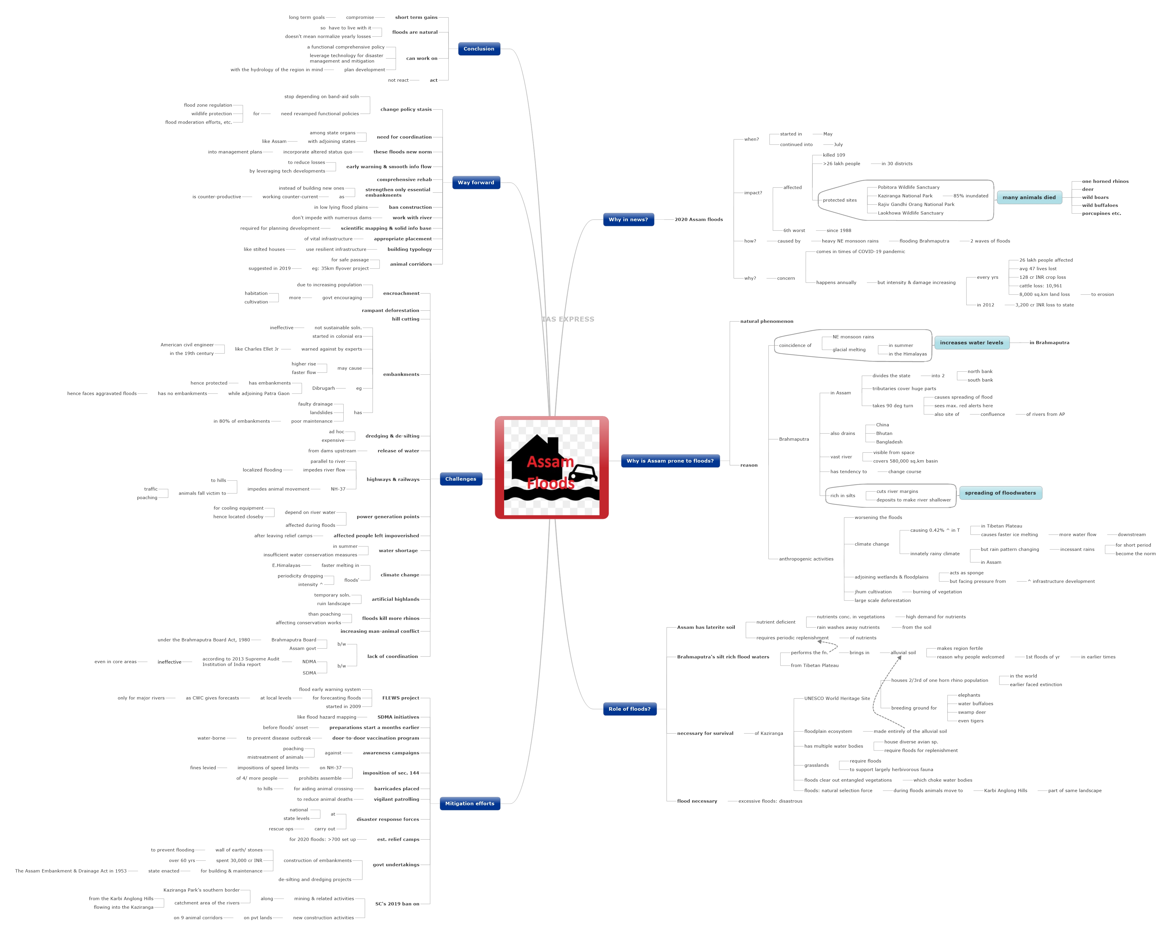
- The annual flooding in Assam is a natural phenomenon. The reason for the annual flooding is that the timing of the north-east monsoons’ precipitation coincides with the glacial melt in the Himalayas in summer. This causes the water level in the Brahmaputra to rise.
- The River Brahmaputra runs through the state cutting it into 2 parts– the north bank and the south bank. The river also drains China, Bhutan and Bangladesh.

- The Brahmaputra is a vast river- even visible from space– and its basin covers 580,000 sq.km.
- It has a tendency to change course and its tributaries cover a huge area of the state.
- It takes a 90 degree turn in the state which causes a larger spreading of the flood waters. The location of this turn is where the maximum number of red alerts are issued.
- This is also the site where rivers from Arunachal Pradesh join the Brahmaputra- exacerbating the flooding every year.
- However, anthropogenic activities have worsened the floods and their impacts.
- The climate change is causing a 42% increase in temperature in the Tibetan Plateau, where the Brahmaputra originates. This increases the melting of ice and consequently, the flow of water down-streams.
- Assam innately has a rainy climate. But there has been a change in the rain patterns in the area. Incessant rains for short periods has become the norm.
- Apart from this, increasing infrastructural development on the adjoining wetlands and floodplains have increased the impact of the floods. These stretches function as sponge in their original form.
- The practice of jhum cultivation, which involves burning of vegetation, removes the trees which provided protection. In addition to this, large scale deforestation also contributes to the damages.
- The river and its tributaries are rich in silt and hence has a greater tendency to cut the river margins. The silt gets deposited and makes the river progressively shallower. This causes the spreading of the flood waters.
What is the role of floods in Kaziranga?
- The Brahmaputra River is a threat to the region but is also an important lifeline.
- The Assam region has laterite soil that is deficient in nutrients. Most of the nutrients in this ecosystem is concentrated in the vegetation of the area. In addition to this, the incessant rains washes away what little nutrients the soil holds.
- The vegetation of the region has a high demand for nutrients because of their dense nature.
- This implies that a periodic replenishment of the soil nutrients is needed to sustain the ecosystem in Assam. The annual floods help perform this function.
- The Brahmaputra brings in silt from the Tibetan Plateau and spreads the alluvial deposits across the region- making it fertile for the native vegetation and also agriculture. This is the reason why people welcomed the first floods on the year in earlier times.
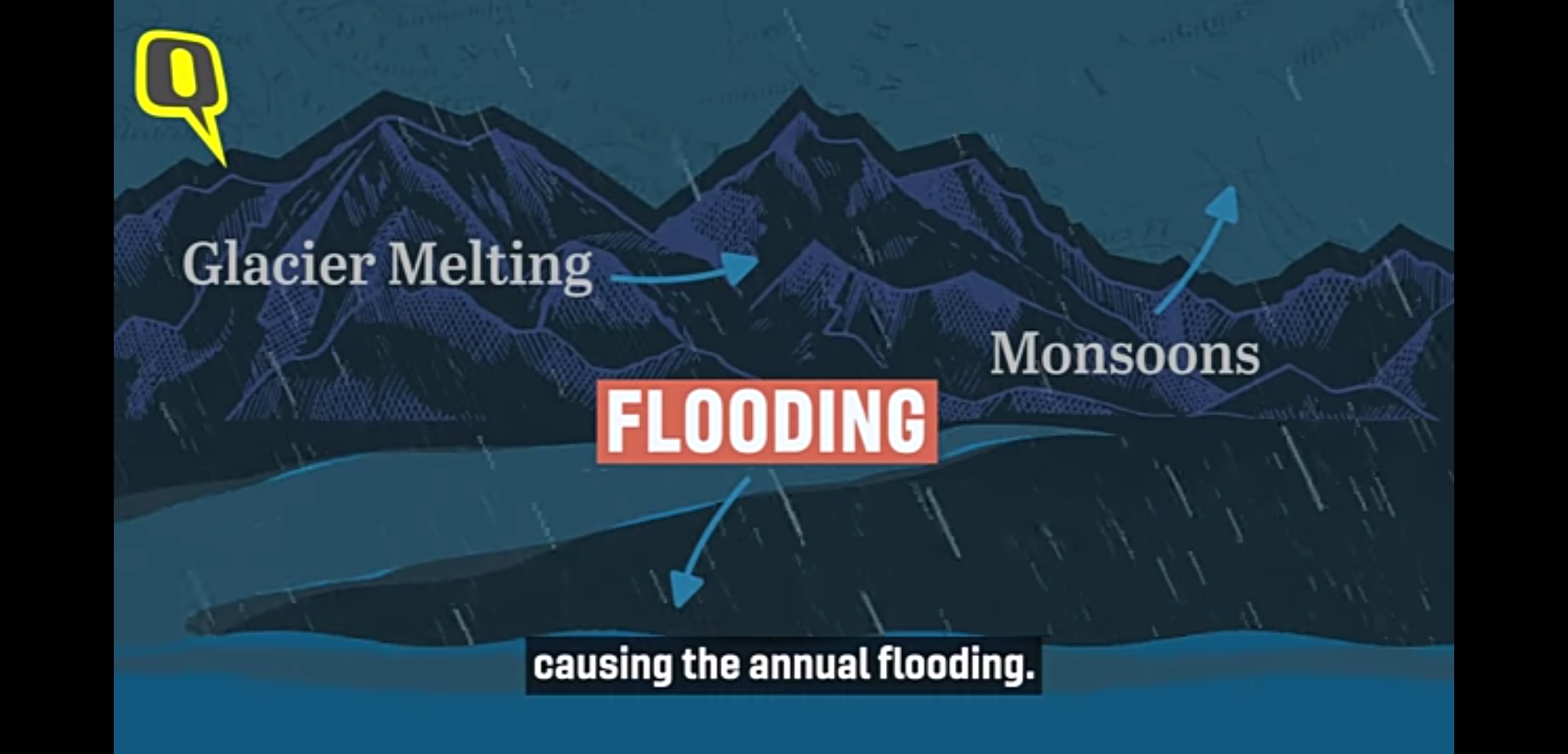
- The flooding is necessary for the very survival of the Kaziranga National Park. This is a UNESCO World Heritage Site situated between the Brahmaputra and the Karbi Anglong Hills and supports 2/3rd of the world’s population of One Horned Rhinos– a species that faced extinction in the past. It is also a breeding ground for elephants, water buffaloes, swamp deer and even tigers.
- The Kaziranga requires the flood as a virtue of its ecosystem- a floodplain ecosystem. This means that the entire area was formed from the alluvial soil from the floods.
- They replenish the multiple water bodies distributed across the Park. These support rich and diverse populations of avian species.
- It helps maintain the grasslands in Kaziranga as it fauna is mainly herbivorous.
- The floods are also required to clear out the entangled vegetation that choke the water bodies.
- The floods are also considered as a natural selection force– killing off the sick and weaker animals while the stronger individuals survive.
- The animals cross over to the Karbi Anglong Hills which also part of the same landscape as Kaziranga during the floods.
- Hence, while these floods are necessary, it is the excessive flooding that turns disastrous.
What has been done to mitigate the impact of the floods?
- The FLEWS project (Flood Early Warning System) was developed for forecasting floods at a more local level as the Central Water Commission issues forecasts and warning only for the major rivers. It started functioning in 2009.
- The State Disaster Management Authority has taken other initiatives like flood hazard mapping.
- The preparations for the flood starts a month before its actual onset.
- Door-to-door vaccination program is conducted before the flood season to prevent outbreak of water-borne diseases.
- Awareness campaigns are launched against poaching and mistreatment of wildlife which become vulnerable during the floods.
- During the floods, Section 144 (prohibiting assembly of 4 or more people) is imposed on the National Highway 37 (NH-37) which passes through the Kaziranga National Park. In addition to this, speed limits are imposed and fines are levied.
- Barricades are placed to help the wild animals cross over to the Karbi Anglong Hills.
- Vigilant patrolling is used to reduce animal deaths.
- During the flooding, the national and state disaster response forces are engaged in rescue operations.
- Relief camps are set up. For the 2020 floods, over 700 relief camps have been set up.
- Artificial highlands have been created within the National park to provide refuge to the animals during inundation. By 2016-17, 33 such structures had been built.
- Over the years, the state government has developed embankments along the river to curb the floods. Embankments are walls of stone or earth to prevent the river from flooding an area. Over the last 6 decades, 30,000 crore INR has been spend on these structures.
- The state enacted The Assam Embankment & Drainage Act in 1953 to build and maintain these structures.
- The government has also undertaken de-silting and dredging projects on the rivers.
- In 2019, the Supreme Court banned mining and related activities along the Kaziranga Park’s southern border and in the catchment area of the rivers from the Karbi Anglong Hills, flowing into the Kaziranga. It also banned new construction activities on privately owned lands on 9 animal corridors.
What are the challenges?
- Encroachment of the banks due to increasing population. The government itself is encouraging more habitation and cultivation of these areas.
- Rampant deforestation and hill cutting is worsening the situation.
- The embankments are not a sustainable solution. The increasing flood intensity is a testament to their ineffectiveness. They were introduced in the colonial era when Assam and Bihar were being considered for cash crop cultivation by the British.
- Even in the 19th century, several experts like the American civil engineer Charles Ellet Jr cautioned against the use of embankments to confine rivers as they caused them to rise higher and flow faster.

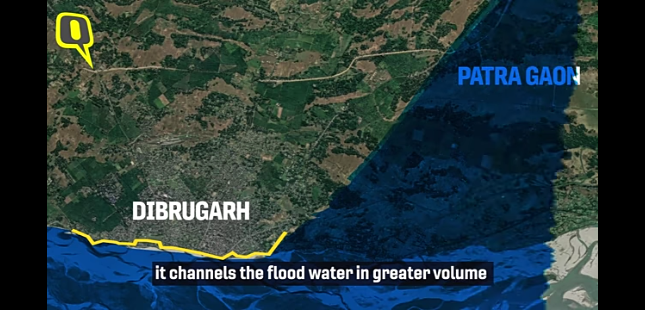
- Case in point: consider the case of Dibrugarh which has embankments while the adjacent Patra Gaon doesn’t. When the floods come in, Dibrugarh is protected but it channels the floods in greater volume and intensity towards Patra Gaon. Because of this, Patra Gaon faces a greater impact than usual while Dibrugarh stays protected.
- Apart from this, landslides and faulty drainage has weakened many embankments. 80% of these structures are poorly maintained.
- Other measures like dredging of rivers are only ad hoc in nature and tends to be expensive.
- The release of excess water from the dams upstream also adds to the problem.
- Major highways and railway lines are running almost parallel to the river. Such infrastructural development impedes the natural flow of the river and increases localized flooding.
- Power generation points in Assam are connected to water system as the river water is used to cool the equipment. Hence, these points are located close to the river and are susceptible to breakdown in times of floods. Due to this, power supply is disrupted especially in times and places of needs- like in hospitals.
- The affected population often end up impoverished after leaving the protection of relief camps.
- Ironically, Assam faces water shortages in summer. This is a consequence of insufficient water conservation measures.
- Climate change is causing the glaciers on the Eastern Himalayas to melt at a faster rate. It is causing an increase in intensity of the floods while its periodicity is declining.
- The artificial highlands are only a temporary solution and they ruin the grassland landscape. Additionally, the older structures are dilapidated.
- The NH-37 makes it difficult for the animals to cross over to the Hills as the highway divides the Kaziranga from the Karbi Anglong region. As a result, these animals fall victim to vehicular traffic or poaching in times of the floods.
- The floods kill more rhinos than poaching in Kaziranga. Other animals are also killed in large numbers during floods- throwing a spanner in the conservation
- The wild animals often stray into human habitations while trying to escape the floodwaters. This increases man- animal conflict.
- On the decision making front, there is a lack of coordination between the Brahmaputra Board (under the Brahmaputra Board Act, 1980) and the Assam government. There is also lack of coordination between the National Disaster Management Authority and the State Disaster Management Authority in Assam.
- The 2013 Supreme Audit Institution of India report noted that the NDMA was ineffective in most of the core areas with even the rescue and relief teams being inadequately trained.
What is the way forward?
- The state of policy stasis must be changed. The government should no longer depend on Band-Aid solutions like embankments, de-silting and dredging. A revamped functional policy for flood zone regulation, wildlife protection, flood moderation efforts, etc.- especially in the upper catchment areas– is the need of the hour.
- There should be coordination among the different state organs concerned with flood management.
- Coordination of Assam with the adjoining states like Meghalaya is also necessary for a coordinated effort.
- It should be noted that these floods have become the new norm and given the fact that climate change is a global phenomenon that can’t be addressed only locally, there is a need to take into account the altered status quo for the flood management plans.
- Early warning and smooth information sharing is the key to reducing the losses due to these floods. Technological developments could be leveraged for this.
- Rehabilitation should be done in a more comprehensive
- Instead of building more and more embankments, only those that are essential must be strengthened. This is because, working counter-current to the river’s hydrology is counter-productive.
- Construction on low lying floodplains must be strictly banned.
- There is a need to work with the river and not against it. It should not be impeded with numerous dams.
- Scientific mapping and developing a solid information base is a primary requirement for planning development going forward. There is a need to identify zones where there must be no activities, zones where agriculture can be practiced and zones where habitations can be developed.
- Appropriate placement of vital infrastructure.
- Building typology must be adapted for the local conditions. Instead of the single floor structures constructed out of weak materials, resilient infrastructure must be developed. Eg: stilted housing to reduce inundation.
- Animal corridors must be secured to ensure a safe passage to the hills. A 35 km long flyover project was proposed by the centre in 2019 for this purpose. The artificial highlands in the National Parks are only temporary refuges.
Conclusion
With respect to the Assam floods, it should be remembered that short term gains will compromise our long term goals. These floods are something to live with for they are a natural occurrence. What can be done is bring in a functional comprehensive policy, leverage technology for disaster management and mitigation and plan development with the hydrology of the region in mind. This doesn’t mean that the yearly destruction should be normalized. It calls for action and not reaction.
Practice question for mains
Explain why the Assam floods continue to cause major damage to life and property despite being an annual event that has been occurring since time immemorial. (250 words)
Related Posts


If you like this post, please share your feedback in the comments section below so that we will upload more posts like this.

Responses