
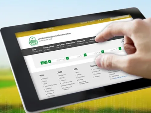
Digitization of Land Records in India | DILRMP Programme
From Current Affairs Notes for UPSC » Editorials & In-depths » This topic
Digitization of land records refers to the process of converting physical land records such as title deeds, survey maps, record of rights etc. into digital formats. It aims to modernize land records management in India and provide better access to land ownership information. The key objectives include improving transparency, reducing land disputes, enhancing governance, and empowering citizens.
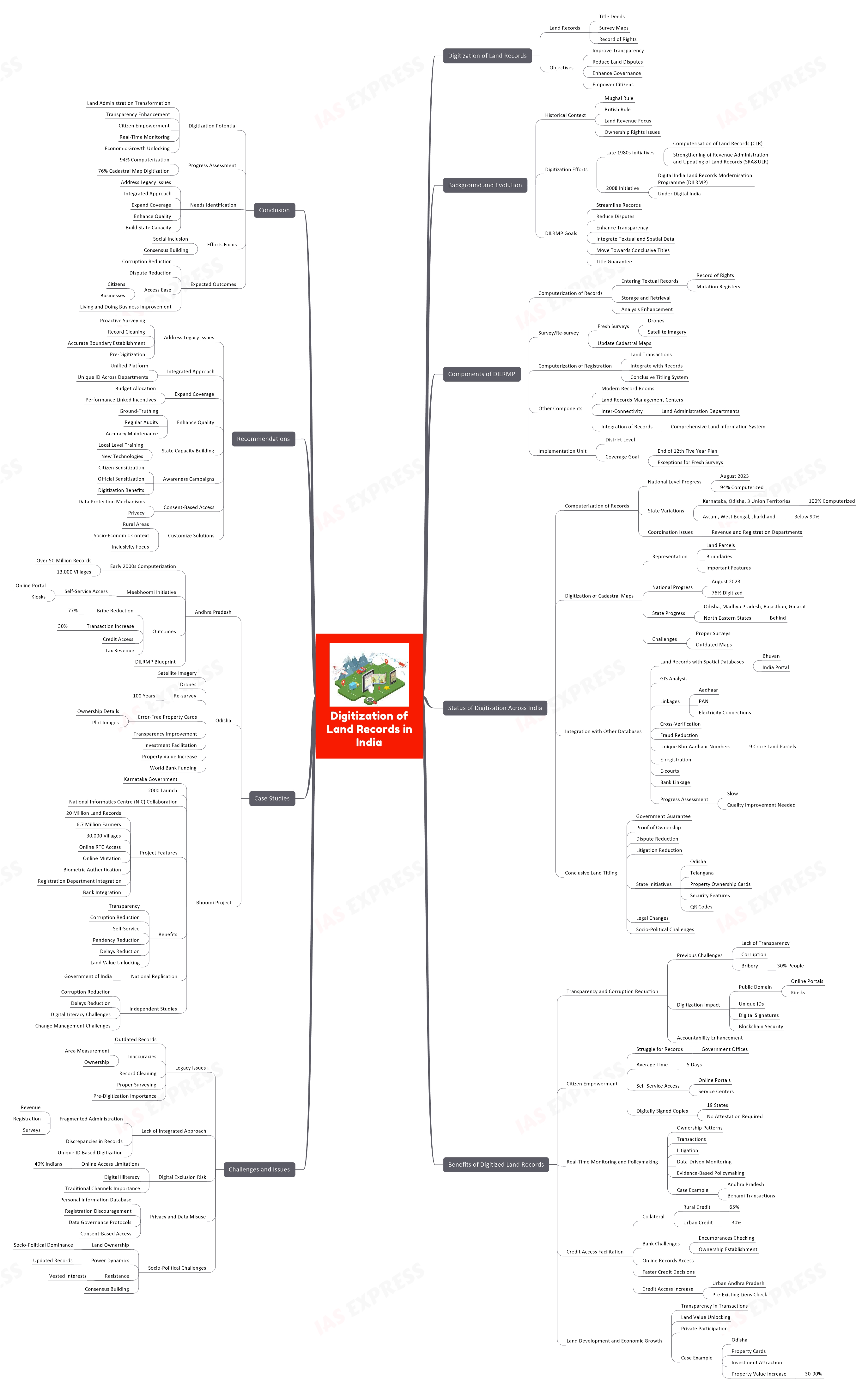
Background and Evolution
The land records system in India has a complex history, evolving from systems implemented during Mughal and British rule which focused more on land revenue collection rather than establishing clear ownership rights. This resulted in inaccuracies and discrepancies over time.
Efforts to computerize and digitize land records were initiated in late 1980s under schemes like Computerisation of Land Records (CLR) and Strengthening of Revenue Administration and Updating of Land Records (SRA&ULR). This gradually evolved into the 2008 Digital India Land Records Modernisation Programme (DILRMP) under the Digital India initiative.
DILRMP aims to streamline land records, reduce disputes, enhance transparency, integrate textual and spatial data, and move towards conclusive titles with title guarantee. Significant progress has been made but gaps remain in achieving key objectives.
Components of DILRMP
- Computerization of land records:
- Involves entering and digitizing textual records like record of rights, mutation registers etc. into databases
- Enables easier storage, retrieval and analysis of records
- Survey/Re-survey:
- Involves conducting fresh surveys using drones and satellite imagery to establish accurate boundaries
- Updating outdated cadastral maps showing land parcel boundaries
- Computerization of registration:
- Computerization of the registration process for land transactions
- Enables integration of registration records with textual and spatial land records
- Aims to move towards a system of conclusive titling
- Other components include:
- Modern record rooms and land records management centers
- Inter-connectivity across land administration departments
- Integration of textual and spatial records into a comprehensive land information system
The district is the unit for implementation with convergence of all activities. The aim is to achieve coverage across all districts by the end of 12th Five Year Plan, except where fresh surveys are needed.
Status of digitization across India
- Computerization of land records
- As of August 2023, around 94% of land records have been computerized at the national level. However, there is a wide variation across states – while Karnataka, Odisha and 3 Union Territories have achieved 100% computerization, states like Assam, West Bengal and Jharkhand are still below 90%. Lack of coordination between revenue and registration departments has hampered progress in some states.
- Digitization of cadastral maps
- Cadastral maps spatially represent land parcels within a jurisdiction by showing boundaries and important features. Digitizing these maps and integrating with land record databases can greatly enhance transparency and analysis.
- As of August 2023, around 76% of the cadastral maps in India have been digitized. States like Odisha, Madhya Pradesh, Rajasthan and Gujarat have made good progress but most North Eastern states are lagging behind. Lack of proper surveys and outdated maps pose key challenges.
- Integration with spatial and other databases
- In addition to computerization and digitization, integration of land records with spatial databases and platforms like Bhuvan, India Portal etc. enables advanced GIS analysis. Linkages with other databases like Aadhaar, PAN, electricity connections etc. allows cross-verification and reduces fraud.
- 9 crore land parcels have been assigned unique Bhu-Aadhaar identification numbers to enable integration. E-registration, E-courts and bank linkage of land records is also being pursued. However, progress is slow and quality of integration needs improvement.
- Conclusive land titling
- The DILRMP aims to eventually provide government guaranteed conclusive land titles that serve as indisputable proof of ownership. This is expected to significantly reduce land disputes and litigation.
- Some states like Odisha and Telangana have introduced provisional individual property ownership cards with security features and QR codes. However, conclusive titling would require significant legal changes and faces socio-political challenges.
Benefits of digitized land records
- Improves transparency and reduces corruption
- Lack of transparency and widespread corruption has plagued land administration in India for decades. Nearly 30% of people have to pay bribes to officials for land-related work.
- Digitization brings land records into the public domain through online portals, kiosks etc. making the system more transparent. Unique IDs, digital signatures, and blockchain-based security features reduce chances of unauthorized changes. This enhances accountability and helps curb corruption over time.
- Empowers citizens
- Citizens often struggle to obtain copies of land records from government offices. Average time taken is estimated to be 5 days according to a NCAER survey. Digitization enables self-service access for citizens through online portals and service centers.
- 19 states have started issuing digitally signed record of rights copies that don’t require attestation. This saves time, effort, and harassment for common citizens.
- Enables real-time monitoring and policymaking
- With digitized land records integrated across domains, governments can track ownership patterns, transactions, litigation etc. in real-time. This allows data-driven monitoring and evidence-based policy making.
- For instance, computerization helped Andhra tackle the issue of Benami transactions in urban areas. Analysis revealed that only 25% of owners in cities occupied their properties while the rest were living elsewhere.
- Facilitates credit access using land as collateral
- Nearly 65% of rural credit and 30% of urban credit in India is collateralized by land and property. However, banks face difficulties in checking encumbrances and establishing ownership.
- Digitization helps banks access and verify records online, enabling faster credit decisions. This was found to increase credit access in urban Andhra Pradesh by enabling banks to check for pre-existing liens.
- Boosts land development and economic growth
- By enhancing transparency in land transactions, digitization helps unlock land value and promotes productive use of land through private participation.
- In Odisha, individual property cards helped attract investment for land development. Property values also increased by 30-90% in areas with updated records.
Challenges and issues
- Legacy issues with land records
- Most land records in India are outdated and inaccurate with errors in area measurement, ownership etc. Simply digitizing such flawed records will only propagate these problems further. Significant effort is essential to clean records and survey lands properly before digitizing.
- Lack of integrated approach
- Land administration in India is fragmented across revenue, registration, surveys etc. Each department works in silos resulting in discrepancies in records. An integrated approach is essential for unique ID based digitization.
- Risk of digital exclusion
- While online access improves transparency, nearly 40% of Indians don’t have internet access. Digital illiteracy poses further barriers. Traditional channels for obtaining records must co-exist to ensure inclusivity.
- Privacy and data misuse concerns
- Any database with personal information raises privacy concerns which may discourage registration of land transactions. Data governance protocols and consent-based access mechanisms need to be institutionalized.
- Socio-political challenges
- Land ownership often correlates to socio-political dominance in rural India. Updated records revealing accurate ownership can alter power dynamics and face resistance from vested interests. Consensus building is key.
Case studies
- Andhra Pradesh
- Andhra Pradesh pioneered computerization of land records in the early 2000s which covered over 50 million records across 13,000 villages. This e-governance initiative called Meebhoomi enabled self-service access through online portal and kiosks.
- Key outcomes included – 77% reduction in bribes, 30% increase in registered transactions, higher credit access, and tax revenue. This success story served as a blueprint for Digital India Land Records Modernization Programme.
- Odisha
- Odisha leveraged advanced satellite imagery and drones to resurvey lands and update records including maps after nearly 100 years. Error-free individual property cards with ownership details and plot images were provided.
- This improved transparency, facilitated investment in land development, and increased property values substantially. Odisha also attracted funding from the World Bank for scaling up efforts.
- Bhoomi Project
- The Bhoomi project was launched by the Government of Karnataka in 2000 to computerize land records and enable online updating of records. It was implemented in collaboration with the National Informatics Centre (NIC).
- Key features of the project:
- Digitization of 20 million land records pertaining to 6.7 million farmers across 30,000 villages
- Online portal for farmers to access and print record of rights (RTC) on demand
- Online mutation to update land records based on transactions like sale, inheritance etc.
- Biometric authentication (fingerprints) to avoid fraud
- Integration with registration department, banks etc. to enable online mutations
- Benefits of Bhoomi:
- Increased transparency in land records reducing corruption
- Empowered citizens by enabling self-service access to records
- Reduced pendency and delays due to automated workflow
- Unlocked land value by establishing clear titles
- The Bhoomi model has been recognized as one of the most successful e-governance initiatives in India. The Government of India is replicating this model nationwide for land record computerization.
- Independent studies on Bhoomi effectiveness have indicated benefits like reduced corruption and delays for farmers in obtaining records but issues like digital literacy, change management challenges etc. persist in some areas.
Recommendations
While significant progress has been made towards digitization of land records, a concerted push is vital to take efforts to the last mile. Some key recommendations in this direction are:
- Address legacy issues proactively by surveying lands, cleaning records and establishing accurate boundaries before digitizing
- Adopt an integrated approach with a unified platform and unique ID across departments
- Expand coverage of computerization and digitization through sufficient budget allocation and performance linked incentives
- Enhance quality through mandatory ground-truthing and regular audits to maintain accuracy
- Build state capacity and skills at local levels through training programs on new technologies
- Launch awareness campaigns to sensitize citizens and officials on digitization benefits
- Develop consent-based access protocols and data protection mechanisms for privacy
- Customize solutions for rural areas keeping in view socio-economic context with focus on inclusivity
Conclusion
In summary, digitization of land records has immense potential to transform land administration in India by enhancing transparency, empowering citizens, enabling real-time monitoring and unlocking economic growth.
While good progress has been made with 94% computerization and 76% digitization of cadastral maps, there is a need to address legacy issues, take an integrated approach, expand coverage, enhance quality, and build state capacity to take digitization to the last mile.
With conscientious efforts focused on social inclusion and consensus building, digitized land records could significantly reduce corruption, land disputes, and ease access for citizens thereby improving ease of living and doing business.
Practice Question for Mains
Discuss the challenges and potential benefits of digitizing land records in India, emphasizing the need for an integrated approach and addressing legacy issues. (250 words)
Related Posts

If you like this post, please share your feedback in the comments section below so that we will upload more posts like this.

Responses