
Gram Manchitra app
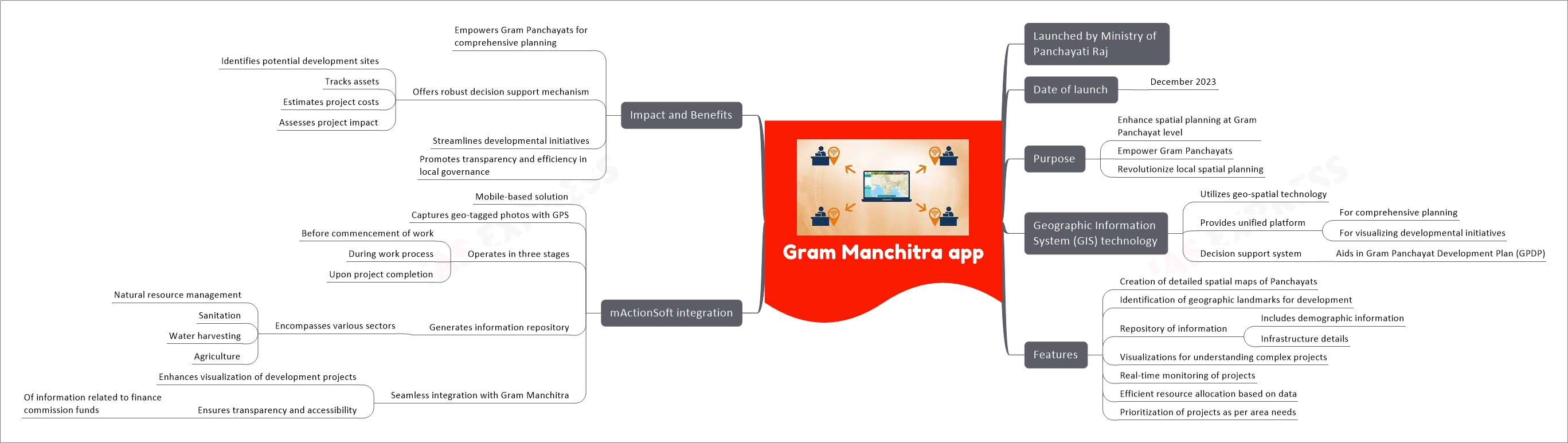
In a groundbreaking move, the Ministry of Panchayati Raj in India launched the Gram Manchitra app in December 2023. This innovative Geographic Information System (GIS) application is set to transform spatial planning at the Gram Panchayat level. The introduction of this technology marks a significant step towards empowering local governance with advanced geo-spatial capabilities.
Key Aspects of Gram Manchitra App
Launch and Purpose
- Launched by: Ministry of Panchayati Raj
- Launch Date: December 2023
- Primary Objective: Enhancing spatial planning at the Gram Panchayat level
- Goal: Empower Gram Panchayats and revolutionize local spatial planning
Utilization of Geographic Information System (GIS) Technology
- Technology Used: Geo-spatial technology
- Unified Platform: Facilitates comprehensive planning and visualization of developmental initiatives
- Decision Support System: Assists in the creation and execution of the Gram Panchayat Development Plan (GPDP)
Features of the Gram Manchitra App
- Spatial Maps Creation: Allows detailed mapping of Panchayats
- Landmark Identification: Helps in identifying key geographic landmarks for development projects
- Information Repository: Acts as a database for demographic and infrastructure details
- Project Visualizations: Provides clear visualizations to understand complex development projects
- Real-time Monitoring: Enables monitoring of ongoing projects
- Resource Allocation: Supports efficient allocation of resources based on data-driven insights
- Project Prioritization: Aids in prioritizing projects according to area-specific needs
Integration with mActionSoft
- Solution Type: Mobile-based solution for capturing geo-tagged photos
- GPS Utilization: Uses GPS coordinates for accurate geo-tagging
- Operational Stages:
- Prior to the commencement of development work
- During the work process
- Upon project completion
- Information Repository Creation: Encompasses various sectors like natural resource management, sanitation, water harvesting, and agriculture
- Integration with Gram Manchitra: Enhances visualization and ensures transparency in the usage of finance commission funds
Impact and Benefits of the Gram Manchitra App
- Comprehensive Planning Empowerment: Equips Gram Panchayats for all-encompassing planning
- Decision Support Mechanism: Provides a robust system for site identification, asset tracking, cost estimation, and impact assessment
- Streamlining Developmental Initiatives: Simplifies and optimizes developmental processes
- Promoting Transparency and Efficiency: Fosters openness and effectiveness in local governance
The Gram Manchitra app stands as a pivotal advancement in the field of local governance in India. By integrating advanced GIS technology, it not only streamlines developmental initiatives but also enhances transparency and efficiency within the Gram Panchayats. This tool is a testament to the potential of technology in transforming the landscape of rural planning and governance.
Related Posts
If you like this post, please share your feedback in the comments section below so that we will upload more posts like this.

Responses