
Geospatial Intelligence
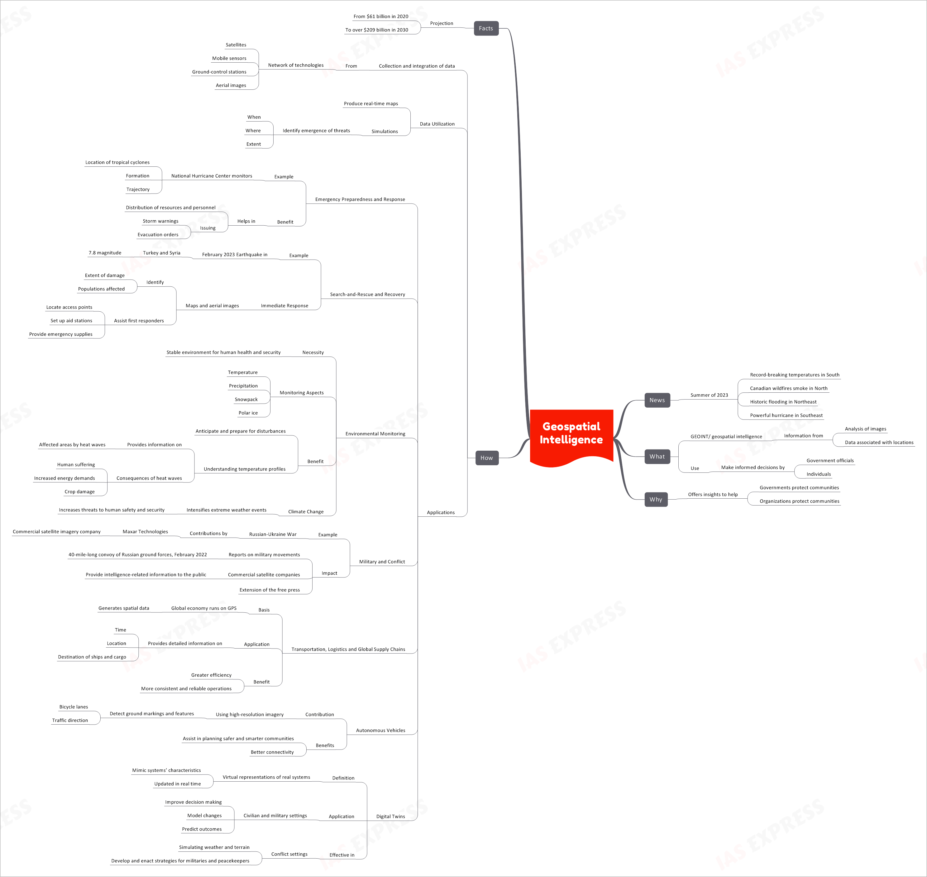
In the summer of 2023, the world is experiencing a series of extreme weather events, from record-breaking temperatures in the South to Canadian wildfires in the North and historic flooding in the Northeast. These events underscore the critical role of geospatial intelligence (GEOINT) in providing valuable insights to protect communities and make informed decisions.
Introduction
Recent news headlines are filled with alarming reports of climate-related disasters and global crises. Geospatial intelligence, abbreviated as GEOINT, has emerged as a powerful tool in addressing these challenges by offering crucial insights and data-driven decision-making capabilities.
Purpose
The primary purpose of GEOINT is to offer valuable insights that help both governments and organizations protect their communities. This information is instrumental in mitigating the impact of natural disasters, understanding military movements, enhancing transportation and logistics, and even contributing to the development of autonomous vehicles.
Definition of GEOINT
GEOINT, or geospatial intelligence, involves the collection and analysis of information from various sources, primarily focusing on the spatial aspect of data. This data includes:
- Analysis of Images: GEOINT involves the analysis of images, which can be obtained from various sources, such as satellites, aerial images, and ground-control stations.
- Data Associated with Locations: Beyond images, GEOINT considers data associated with specific locations, including GPS coordinates, environmental conditions, and more.
The Use of GEOINT
GEOINT is used to make informed decisions by government officials and individuals alike. This includes assessing environmental conditions, monitoring military activities, and optimizing transportation and logistics.
The GEOINT Process
The process of geospatial intelligence involves the collection and integration of data from a network of technologies. These technologies encompass:
- Satellites: GEOINT relies heavily on satellite imagery to obtain real-time data and images of the Earth’s surface.
- Mobile Sensors: Ground-based sensors and mobile devices provide valuable data on various parameters, including weather conditions and environmental factors.
- Ground-Control Stations: These stations play a pivotal role in controlling and directing satellite operations, ensuring accurate data collection.
- Aerial Images: In addition to satellite imagery, aerial images captured by aircraft are integrated into the GEOINT process.
Data Utilization
The data collected through these technologies is used to produce real-time maps and simulations, helping to identify the emergence of threats such as natural disasters or military movements. This includes pinpointing when and where these events occur and the extent of their impact.
Applications of GEOINT
The applications of GEOINT are diverse and far-reaching, encompassing several critical areas:
Emergency Preparedness and Response
Example: The National Hurricane Center uses GEOINT to monitor the location, formation, and trajectory of tropical cyclones.
Benefits: This aids in the distribution of resources and personnel, as well as the issuance of timely storm warnings and evacuation orders.
Search-and-Rescue and Recovery
Example: In the aftermath of the February 2023 earthquake in Turkey and Syria (with a magnitude of 7.8), GEOINT provided immediate response capabilities.
Immediate Response: Maps and aerial images were used to identify the extent of damage, populations affected, and to assist first responders in locating access points, setting up aid stations, and providing emergency supplies.
Environmental Monitoring
Necessity: GEOINT plays a crucial role in ensuring a stable environment for human health and security.
Monitoring Aspects: This includes monitoring temperature, precipitation, snowpack, polar ice, and more.
Benefits: GEOINT enables the anticipation and preparation for disturbances, such as heatwaves, and provides insights into the consequences of extreme weather events, including human suffering, increased energy demands, and crop damage.
Military and Conflict
Example: In the context of the Russian-Ukraine War, commercial satellite imagery companies like Maxar Technologies have made significant contributions.
Impact: GEOINT reports on military movements, such as the identification of a 40-mile-long convoy of Russian ground forces in February 2022. This extends the role of commercial satellite companies as contributors to intelligence-related information available to the public, effectively acting as an extension of the free press.
Transportation, Logistics, and Global Supply Chains
Basis: The global economy heavily relies on GPS and spatial data, which GEOINT generates.
Application: GEOINT provides detailed information on the time, location, and destination of ships and cargo, ensuring greater efficiency and more consistent and reliable operations within global supply chains.
Autonomous Vehicles
Contribution: GEOINT assists autonomous vehicles by using high-resolution imagery to detect ground markings and features, including bicycle lanes and traffic direction.
Benefits: This technology contributes to planning safer and smarter communities and enhances overall connectivity.
Digital Twins
Definition: Digital twins are virtual representations of real systems that mimic the characteristics of these systems and are updated in real time.
Application: Digital twins find applications in both civilian and military settings, improving decision-making, modeling changes, and predicting outcomes. In conflict settings, they are valuable for simulating weather and terrain to develop and enact strategies for militaries and peacekeepers.
Industry Growth
The geospatial intelligence industry is experiencing rapid growth, with projections indicating substantial expansion:
- Projection: From a market size of $61 billion in 2020, the industry is expected to surpass $209 billion by 2030.

If you like this post, please share your feedback in the comments section below so that we will upload more posts like this.

Responses