Among the disasters earthquakes are by far the most unpredictable and destructible. India has seen some of the greatest earthquakes in the last century. The turning of the century brought devastating Bhuj earthquake in 2001. Earthquakes are a prominent danger in India’s disaster profile which has caused huge loss of life and material. Recently, powerful tremors were felt in India following an earthquake of magnitude 6.6 that struck Nepal, killing a few people and destroying many homes.
What are Earthquakes?
An earthquake is shaking of the earth caused due to the release of
energy from the earth’s interior, which generates waves that travel in all directions.
An earthquake can range from minor tremors to large building shanking shock.
Minor tremors caused by small vibrations occur every few minutes but great earthquakes happen because of faulting (Normal, reverse and strike-slip) cause a great number of disruptions.
What are the various types of the earthquake?
Tectonic Earthquakes
Generated due to sliding of the rocks along the fault plane.
This is the most commonly occurring type of earthquake.
Volcanic Earthquake
Occur due to volcanic activities and displacement caused because of those.
These are confined to areas of active volcanoes.
Collapse Earthquake
These occur in the areas of intense mining.
Roofs of underground mines collapse that cause tremors.
Explosion Earthquakes
Ground shaking caused by huge explosions like a nuclear explosion and chemical explosion
Reservoir induced Earthquakes
These occur in the areas of huge reservoirs like dams.
As can be seen, unlike some other kinds of disaster, the earthquake zones can be demarcated. The earthquake zone mapping helps in planning for mitigating the losses that occurred due to earthquakes.
India and earthquakes
India has had its share in some of the devastating earthquakes.
More than 58.6% of the Indian land is prone to moderate to very high-intensity earthquakes.
Some of the great earthquakes in India
Cutch Earthquake (1819) which was 8.3 magnitude
Assam Earthquake (1897)
Bihar-Nepal Earthquake (1934) of 8.4 magnitude
Koyna Earthquake (1967) of 6.5 magnitude
Uttarkashi (1991) of 6.6 magnitude
Killari (1993) of 6.4 magnitude
Bhuj (2001) of 7.7 magnitude
Jammu Kashmir (2005)
What are the reasons for the Earthquakes in India?
Himalayan belt– Collision between Indo-Austral plate with Eurasian plate and Burma Plate with Java Sumatra plate. This collision causes lots of strain in underlying rocks’ energy of which is released in the form of earthquakes.
Andaman and Nicobar Islands– Seafloor displacement and underwater volcanoes which disturb the equilibrium of earth’s surface
Deccan Plateau– some earth scientists have come up with a theory of the emergence of a fault line and energy build-up along the fault line of the river Bhima (Krishna) near Latur and Osmanabad (Maharashtra).
Increasing population and unscientific land use in construction make India a high-risk land for earthquakes.
What are the consequences of an earthquake?
Earthquake is characterized by suddenness, scale, and magnitude. These three characters make it extremely dangerous when it comes to life and property without any discrimination. The impacts of the earthquake can be summarized as below
Human loss
Within the period between 1990 and 2006, around 23,000 lives were lost because of major earthquakes in India.
Damage to property
The upheaval caused by an earthquake does huge damage to the property. Especially in a developed area of high population density, the damage to the property is huge.
Changes in the river course
One of the important impacts of the earthquake is the change in the river course due to blockage.
Tsunami
Earthquakes when happening in the ocean basin creates huge waves that strike on the coast creating huge damages. The 2004 Tsunami in Sumatra brought Tsunami to the east coast of India.
Mud fountains
Due to the huge impact of the earthquake, mud and hot water may emerge on the surface. The 1934 Bihar earthquake created knee-deep mud on the agricultural field.
Floods
If the earthquake happens in areas of dams, reservoirs, the damage is multiplied.
The flood may result due to damage caused to the dams.
Landslides and Avalanches
Earthquake in hilly and mountain areas may cause landslides and avalanches
Fire hazards
Earthquakes cause damage to electric property and gas pipes. Due to the havoc caused by the earthquake, it is even difficult to contain the fire.
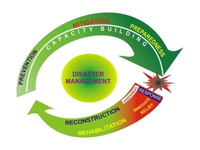
Earthquake management in India
Earthquake management in India, Disaster management for that matter, goes through different stages. Some of the critical areas of earthquake management in India are
Awareness among various stakeholders
Structural mitigation measures
Monitoring and enforcement of earthquake-resistant building codes and appropriate town planning.
Proper earthquake response planning
System of decentralized response
Trained manpower to deal with the disaster
Building back better
Disaster management action plan can be summarized pictographically in the following way
Hence first comes the awareness of earthquake-prone areas. Earthquake mapping is an essential component of that awareness regime.
Earthquake mapping in India
Bureau of Indian Standards [IS 1893 (Part I):2002], has divided the country into four seismic zones, Zone-II, III, IV and V. Zone V is the most active region and zone II is the least seismically active region.
Zone V
Entire northeast India, parts of Jammu and Kashmir, Himachal Pradesh, Uttaranchal, Rann of Kutch in Gujarat, part of North Bihar and Andaman & Nicobar Islands.
Zone IV
Parts of Jammu and Kashmir and Himachal Pradesh, Delhi, Sikkim, parts of Gujarat and small portions of Maharashtra near the west coast, Rajasthan, Northern Parts of Uttar Pradesh, Bihar and West Bengal.
Zone III
Remaining parts of Uttar Pradesh, Gujarat and West Bengal, Parts of Punjab, Rajasthan, Madhya Pradesh, Bihar, Jharkhand, Chhattisgarh, Kerala, Goa, Lakshadweep islands, Maharashtra, Orissa, Andhra Pradesh, Tamil Nadu, and Karnataka.
Zone II covers remaining parts of the country
The earthquake preparedness, rather disaster management, and preparedness was an evolutionary road.
The Indian government set up a High-Powered Committee in 1999 and a National Committee after the Gujarat earthquake, to make recommendations on effective preparedness and mitigation mechanisms.
The Tenth Five-Year Plan document included a detailed chapter on Disaster Management.
The Twelfth Finance Commission was mandated to review the financial arrangements for Disaster Management and preparedness.
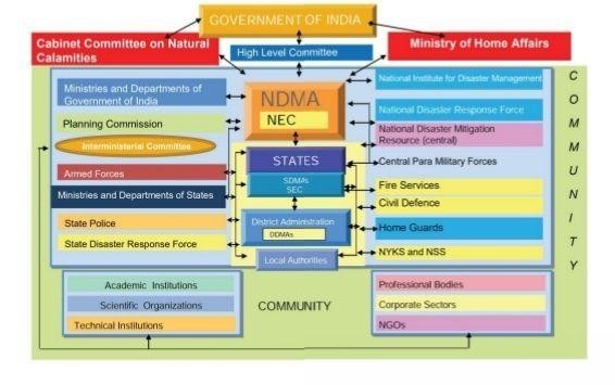
In December 2005, the Disaster Management Act was enacted
The Disaster management act envisaged the creation of
National Disaster Management Authority (NDMA), headed by the Prime Minister
to implement activities of Disaster Management in India
State Disaster Management Authorities (SDMAs) headed by respective Chief Ministers to do the same at the state level.
Earthquake is an essential part of India’s disaster preparedness challenges.
Structure of NDMA
Some Important measures to prevent and mitigate earthquake loss
The National Center for Seismology
An office of the Ministry of Earth Sciences. It submits earthquake surveillance and hazard reports to governmental agencies.
It includes three divisions: Earthquake Monitoring & Services, Earthquake Hazard & Risk Assessment, Geophysical Observation System.
National Earthquake Risk Mitigation Project (NERMP)
Strengthening the structural and non-structural dimensions of earthquake mitigation efforts.
reducing the vulnerability in the high-risk districts.
Necessary risk mitigation measures are put in place in the highly seismic zones.
NDMA, tasked with this project has prepared a Detailed Project Report (DPR).
National Building Code (NBC)
Comprehensive building code and a national instrument providing guidelines for regulating the building construction activities across the country.
First published in 1970 at the instance of the Planning Commission and was revised in 1983. Thereafter three major amendments, two in1987 and the third in 1997 were issued.
The revised NBC has now been brought out as National Building Code of India 2005 (NBC 2005).
The salient features are meeting the challenges posed by natural calamities and incorporating the contemporary applicable international best practices.
Building Materials & Technology Promotion Council (BMTPC)
undertakes projects for retrofitting of life-line structures to generate awareness among the people and various government agencies.
aimed to help people at large and the policymakers in particular in working towards reducing the vulnerability of lakhs of existing public and private buildings.
Initiatives by Ministry of Panchayati Raj
It releases funds under Backward Regions Grant Fund (BRGF) for meeting critical infrastructural gaps and other developmental requirements.
The ministry has financed several district plans under the BRGF for construction of panchayat buildings, Anganwadi centres, school buildings, classrooms, roads, bridges, culverts, etc. and restructuring of State Institutes for Rural Development (SIRD) buildings, block resource centres, panchayat training centers, etc.
National Retrofit Program
The NDMA, along with experts from various IITs and requisite ministries, came out with guidelines on ‘seismic retrofitting’.
The National retrofitting Program was launched under the Home Ministry in 2014 following those guidelines.
The RBI had asked the banks to deny loans to any building which does not abide by the earthquake resistant structures’ guidelines.
The government launched two Mobile apps
‘India Quake’– Developed by the National center for seismology, the mobile app disseminates real-time earthquake information.
‘Sagar Vani’-Intended to serve coastal communities, the mobile app disseminates ocean related information and alerts to the user community in a timely manner for their safety.
TheNational Disaster Response Force (NDRF) strives to be the first responder at heritage sites, which are vulnerable to disasters such as earthquakes, floods, cyclones, and tsunami across India.
In Earthquake management scenario in India, The NDMA guidelines of 2007 on earthquake preparedness are very important
According to the guidelines, six pillars of earthquake management are
Earthquake resistant construction of new structures.
Selective seismic strengthening and retrofitting of existing structures.
Regulation and enforcement.
Awareness and preparedness.
Capacity development.
Emergency response.
International cooperation in earthquake preparedness
India is a signatory to the Sendai Framework for Disaster Risk Reduction which works in disaster management in a very holistic way.
India works closely with the United Nations International Strategy for Disaster Reduction (UNISDR).


Responses