Fluvial Landforms – Erosional And Depositional
I. Introduction
What are Fluvial Landforms:
- Fluvial landforms are landforms created by the action of flowing water, including rivers and streams.
- These landforms are shaped by the combined forces of water flow, erosion, and sediment transport, which change over time as water flow conditions change.
Types of Fluvial Landforms:
- Fluvial landforms can be divided into two broad categories: erosional and depositional.
- Erosional fluvial landforms are formed by the removal of material from the channel or banks of a river or stream. Examples include waterfalls, gorges, and meanders.
- Depositional fluvial landforms are formed by the accumulation of material in the channel or banks of a river or stream. Examples include alluvial fans, deltas, and floodplains.
Importance of Fluvial Landforms:
- Fluvial landforms are important ecosystems that provide a range of valuable ecosystem services, including water supply, flood regulation, nutrient cycling, and habitat for a diverse range of plants and animals.
- Understanding fluvial landforms is important for managing and conserving these important ecosystems and the services they provide.
II. Erosional Fluvial Landforms
- Landforms created by the erosion and removal of material by a river or stream.
- Examples include waterfalls, gorges, canyons, meanders, and oxbow lakes.
- These landforms are shaped by the erosive power of moving water, which can cut into and shape the earth’s surface over time.
A. Stream erosion
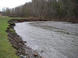
- The process by which a stream or river erodes and removes material from its channel and banks.
- Causes:
- The velocity of the flowing water
- The amount and type of sediment in the water
- The slope and shape of the channel
- The amount of vegetation along the channel
- Types:
- Lateral erosion: occurs along the banks of a stream.
- Vertical erosion: occurs along the bed of a stream.
- Headward erosion: occurs at the upper end of a stream, causing the stream to lengthen and the stream channel to become deeper.
- Downcutting erosion: occurs at the lower end of a stream, causing the stream to shorten and the stream channel to become shallower.
- Result:
- Shaping the channel and its banks, resulting in the formation of different landforms such as V-shaped valleys, waterfalls, and gorges.
- Human impact:
- Activities such as deforestation, urbanization, and agriculture can increase the rate of erosion by increasing the amount of water runoff and removing vegetation that holds soil in place.
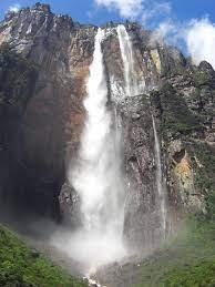
B. Waterfalls and cascades
- Erosional landforms formed by rivers and streams.
- Waterfalls:
- Formed when a river or stream flows over a hard, erosion-resistant rock layer that is overlain by a softer, more easily eroded rock layer.
- The falling water erodes the softer rock and creates a vertical drop.
- Examples: Niagara Falls, Victoria Falls.
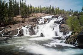
- Cascades:
- Formed when a river or stream flows over a series of rock steps or ledges.
- The falling water creates a series of small drops or rapids.
- Examples: Yosemite Falls, Havasu Falls.
- Human impact: Dams and other human-made structures can create artificial waterfalls by diverting water from a river or stream and dropping it over a dam or other barrier.
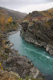
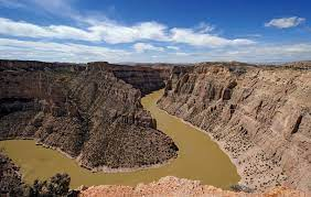
C. Gorges and canyons
Gorges:
– Narrow and steep-sided valleys, often with a river or stream running through the bottom.
– Formed by the erosion of a river or stream over time.
– World examples: The Grand Canyon, the Gorge of the Verdon.
– India examples: The Kali Gandaki Gorge, the Indravati Gorge
Canyons:
– Deep, steep-sided valleys, often with a river or stream running through the bottom.
– Formed by the erosion of a river or stream over time, or by other processes such as glaciation or mass wasting.
– World examples: The Grand Canyon, the Canyonlands
– India examples: The Aravalli Range, The Binsar Mahadev Canyon
Human impact:
– Human activities such as dam building, mining, and logging can accelerate the erosion process and cause significant changes to the landforms.
– Dams can also change the flow of water in a river, leading to changes in erosion patterns and the formation of new landforms.
Note: The main difference between Gorges and Canyons is the size, Gorges are smaller than Canyons but both formed by erosion.
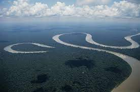
D. Meanders and oxbow lakes
Meanders: – Curved or winding channels of a river or stream. – Formed by the erosion of the outer bank and deposition of sediment on the inner bank. – World examples: The Mississippi River, The Rhine River. – India examples: The Brahmaputra River, The Indus River.
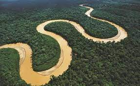
Oxbow Lakes: – Lagoons or ponds that form along the inside of a meander. – Formed when a meandering river erodes the outer bank and deposits sediment on the inner bank, causing the river channel to shift and eventually cut off the old channel, leaving behind a lake. – World examples: Lake Maurepas, Louisiana, Lake Chicot, Arkansas. – India examples: Bhoj Wetland, Madhya Pradesh, Kanwar Lake Bird Sanctuary, Bihar.
Human impact: – Human activities such as dam building, channelization, and extraction of sand and gravel can alter the natural processes of erosion and deposition, leading to changes in the formation and shape of meanders and oxbow lakes. – Agricultural practices, urbanization, and deforestation can also increase erosion and sedimentation in a river or stream, leading to changes in the meandering patterns and the formation of new landforms.
Note: Meanders and Oxbow Lakes are examples of how the processes of erosion and deposition shape fluvial landforms over time.
III. Depositional Fluvial Landforms
- Landforms formed by the deposition of sediment by rivers and streams.
- Deposition occurs when the velocity of the water decreases, causing the sediment to settle out of the water and accumulate on the channel bed or along the banks of the river or stream.
- Examples of depositional fluvial landforms include alluvial fans, deltas, floodplains, and river terraces.
A. Alluvial fans
Alluvial Fans:
- Depositional landform formed by a fan-shaped accumulation of sediment.
- Occur where a river or stream flows from a confined channel onto a flat plain or valley floor.
- Formed by the deposition of sediment as the velocity of the water decreases, causing the sediment to spread out in a fan-shaped pattern.
Features: – Typically composed of coarse-grained sediment such as boulders, cobbles, and gravel. – Can also contain finer-grained sediment such as sand and silt. – Slope angle decreases from the point of origin to the outer edge of the fan.
World Examples: – Death Valley Alluvial Fan, California, USA. – Brahmaputra Alluvial Fan, Tibet, China.
India Examples: – Godavari Alluvial Fan, Andhra Pradesh – Satluj Alluvial Fan, Himachal Pradesh
Human impact: – Human activities such as logging, mining, and urbanization can increase erosion and sedimentation in a river or stream, leading to changes in the formation and shape of alluvial fans. – Agricultural practices, deforestation, and overgrazing can also increase erosion and sedimentation, causing changes in the alluvial fans.
Note: Alluvial fans are important indicators of past and current fluvial processes and environments, and they provide valuable information about the geologic history of an area.
B. Floodplains
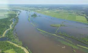
Floodplains:
- Flat areas of land adjacent to a river or stream that are subject to periodic flooding.
- Formed by the deposition of sediment during floods, when the velocity of the water decreases, causing the sediment to settle out of the water and accumulate on the channel bed or along the banks of the river or stream.
Features: – Flat or gently sloping terrain. – Can be composed of sand, silt, clay, or a mixture of sediment types. – Can contain meandering channels, oxbow lakes, and other fluvial landforms.
World Examples: – Mississippi River Floodplain, USA. – Nile River Floodplain, Egypt.
India Examples: – Brahmaputra River Floodplain, Assam. – Ganges River Floodplain, Uttar Pradesh.
Human impact: – Human activities such as dam building, channelization, and urbanization can alter the natural processes of flooding, leading to changes in the formation and shape of floodplains. – Agricultural practices, deforestation, and overgrazing can also increase erosion and sedimentation, causing changes in the floodplains.
Note: Floodplains provide valuable ecosystem services, such as supporting agricultural production, providing habitats for wildlife, and storing water.
C. Deltas
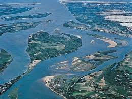
Deltas:
- Depositional landform formed where a river or stream flows into a body of standing water, such as a lake or ocean.
- Occur when the velocity of the water decreases, causing the sediment to settle out of the water and accumulate at the mouth of the river or stream.
Features: – Triangular shaped landform. – Can be composed of sand, silt, clay, or a mixture of sediment types. – Typically contains a network of channels and levees.
World Examples: – Mississippi River Delta, USA. – Nile River Delta, Egypt.
India Examples: – Ganges Delta, West Bengal. – Godavari Delta, Andhra Pradesh.
Human impact: – Human activities such as dam building, channelization, and urbanization can alter the natural processes of delta formation, leading to changes in the shape and size of deltas. – Agricultural practices, deforestation, and overgrazing can also increase erosion and sedimentation, causing changes in the deltas.
Note: Deltas are important for human populations, as they provide fertile agricultural land, rich fishing grounds, and valuable oil and natural gas resources.
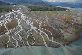
D. Braided channels
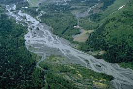
Braided Channels:
- Fluvial landform characterized by a network of interlacing channels separated by sediment bars.
- Occur when the sediment load of a river or stream is high, and the velocity of the water is not strong enough to maintain a single channel.
Features: – Multiple channels that intersect and re-intersect, creating a complex network of channels. – Can be composed of sand, silt, gravel, or a mixture of sediment types. – Bars of sediment can accumulate between the channels, creating low-lying islands.
World Examples: – Brahmaputra River, Tibet. – Klondike River, Alaska, USA.
India Examples: – Brahmaputra River, Assam. – Indus River, Ladakh.
Human impact: – Human activities such as dam building, channelization, and urbanization can alter the natural processes of braided channel formation, leading to changes in the shape and size of braided channels. – Agricultural practices, deforestation, and overgrazing can also increase erosion and sedimentation, causing changes in the braided channels.
Note: Braided channels provide valuable ecosystem services, such as supporting agricultural production, providing habitats for wildlife, and storing water.
IV. Comparison of landforms in different geographic regions
India:
- India is a country with a large and diverse geographic area, ranging from the high Himalayas to the coastal plains. As a result, the country has a wide range of fluvial landforms, including gorges, canyons, alluvial fans, floodplains, deltas, and braided channels.
- The Himalayan rivers, such as the Ganges and the Brahmaputra, have carved deep gorges and canyons in the mountain ranges. These rivers also form large, fertile deltas in the coastal plains.
- The Deccan Plateau in central India is characterized by the presence of large alluvial fans formed by the westward-flowing rivers.
- The coastal plains in India are dotted with numerous deltas, such as the Godavari Delta and the Mahanadi Delta, which are important for agriculture, fishing, and natural resources.
North America:
- The North American continent is characterized by a large variety of fluvial landforms, including gorges, canyons, alluvial fans, floodplains, deltas, and braided channels.
- The Grand Canyon in Arizona, USA, is a well-known example of a canyon formed by the erosive forces of the Colorado River.
- The Mississippi River in the United States forms one of the largest deltas in the world, with a vast network of channels and levees.
- The alluvial fans in the western United States, such as the Mojave Desert, are formed by the convergence of many small streams and rivers.
Africa:
- Africa is a large and diverse continent with a wide range of fluvial landforms, including gorges, canyons, alluvial fans, floodplains, deltas, and braided channels.
- The Nile River in Egypt forms a large delta at its mouth, where it flows into the Mediterranean Sea.
- The Victoria Falls in Zimbabwe and Zambia is a well-known example of a waterfall formed by the Zambezi River.
- The large floodplains in Africa, such as the Okavango Delta in Botswana, provide important habitats for wildlife and support agriculture and fishing.
Note: The comparison of fluvial landforms in different geographic regions highlights the diversity of these landforms and the important role they play in shaping the landscape and providing valuable ecosystem services.
V. Human Impact on Fluvial Landforms
A. Human-induced changes to fluvial landforms
Impacts:
- Human activities, such as dam construction, urbanization, and deforestation, have a significant impact on fluvial landforms and the ecosystems they support.
- These activities alter the flow regimes and sediment transport processes in rivers and streams, leading to changes in the shape and size of fluvial landforms.
- The impacts of human activities on fluvial landforms can range from increased erosion and flooding to reduced sediment supply and altered river channels.
Examples: India:
- The construction of dams and reservoirs in India, such as the Sardar Sarovar Dam on the Narmada River, has altered the flow regimes and sediment transport processes in these rivers.
- The rapid urbanization and deforestation in the Ganges Basin has led to increased erosion and sedimentation in the river, affecting the quality of water and the ecosystem services provided by the river.
World:
- The construction of the Three Gorges Dam in China has significantly altered the flow regime and sediment transport processes in the Yangtze River, leading to changes in the size and shape of the river channel.
- The deforestation in the Amazon Basin has led to increased erosion and sedimentation in the rivers and streams, affecting water quality and ecosystems.
Note: The human-induced changes to fluvial landforms highlight the need for sustainable and responsible land-use practices that minimize the impacts of human activities on these important ecosystems.
B. Mitigation and management strategies
Goals:
- The goal of mitigation and management strategies is to minimize the impacts of human activities on fluvial landforms and to conserve and restore these important ecosystems.
Approaches:
- Sustainable land-use practices, such as reducing deforestation and urbanization, can help reduce the impacts of human activities on fluvial landforms.
- Watershed management and river basin management approaches aim to regulate land-use activities and minimize their impacts on fluvial landforms.
- Restoration of degraded fluvial landforms, such as the removal of artificial structures like dams or levees, can help restore the natural flow regime and sediment transport processes in rivers and streams.
Examples: India:
- The National River Conservation Plan in India aims to protect and conserve India’s rivers and their ecosystems through sustainable land-use practices, river basin management, and river restoration.
- The Ganges River Basin Management Plan in India aims to balance the competing demands of water resources, energy production, and ecological health in the Ganges River Basin.
World:
- The restoration of degraded rivers and streams in the United States, such as the removal of dams and levees, has helped to restore the natural flow regime and sediment transport processes in these systems.
- The European Water Framework Directive aims to ensure the ecological health and sustainable use of Europe’s water resources through integrated river basin management approaches.
Note: Effective mitigation and management strategies are critical for conserving and restoring fluvial landforms and the important ecosystem services they provide. A holistic and integrated approach to river basin management, combining technical, ecological, and social considerations, is essential for achieving sustainable and responsible use of these valuable resources.