
Introduction
A tropical cyclone is a rotating system of low pressure that is primarily found in tropical regions. Unlike temperate cyclones, which are large and spread over thousands of square kilometers, tropical cyclones are relatively smaller systems with high wind velocities, often reaching speeds of 130-150 km/hr. They are known for their devastating impact and are better referred to as “warm core cyclones” due to their thermally induced nature.
Conditions Associated with the Development of Low Pressure
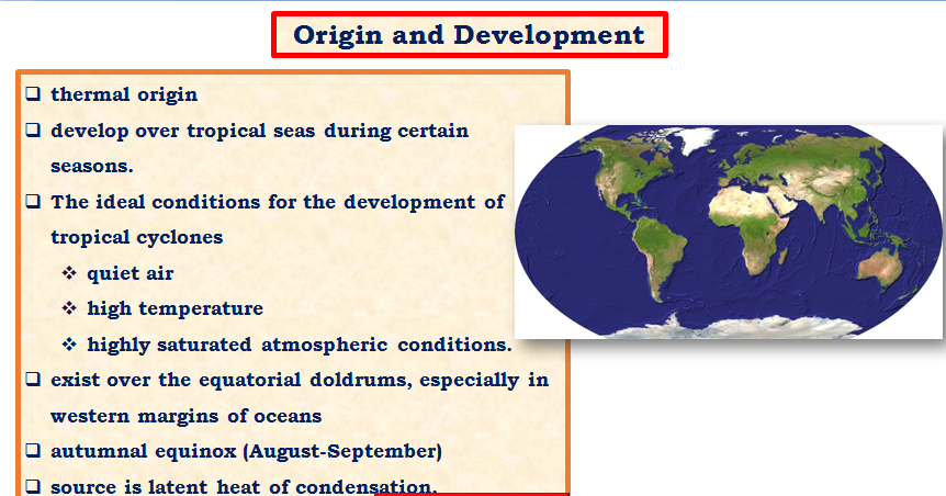
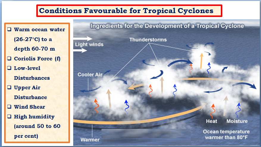
Although tropical cyclones are known to be thermally induced, the precise mechanism behind their formation is still not fully understood. However, there are several factors that have a positive correlation with tropical cyclone development:
- Ocean Water Conditions (Sea Surface Temperature):
- Tropical cyclones require ocean water temperatures of at least 20-27 degrees Celsius to develop and sustain their strength.
- Tropical cyclones do not originate in eastern tropical waters due to relatively lower temperatures.
- Northern tropical waters, which are relatively warmer, have a higher frequency of tropical cyclones.
- Areas of upwelling, where warmer water is found in late summers, experience a higher frequency and intensity of cyclones, particularly in September and early October.
- Cold currents can also influence the development and sustainability of tropical cyclones.
- Formation Over Water:
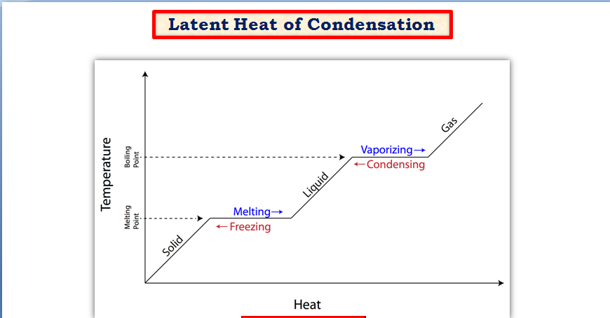
- Tropical cyclones always form over water because they require the latent heat of condensation to keep the air warm and facilitate cyclone maturation.
- With landfall, tropical cyclones dissipate and die off due to the cut-off of moisture supply.
- Coastal Location:
- Tropical cyclones are primarily features of coastal locations and differ from thunderstorms and cloudbursts, which tend to occur further inland away from the sea.
- Latitude and Pressure Systems:
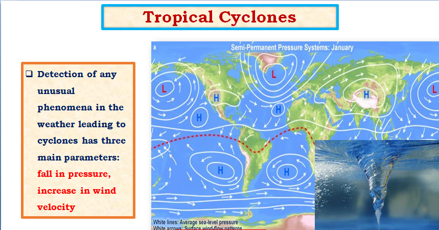
- Tropical cyclones are never formed at the equator and are more common in regions around 8-10 degrees north latitude.
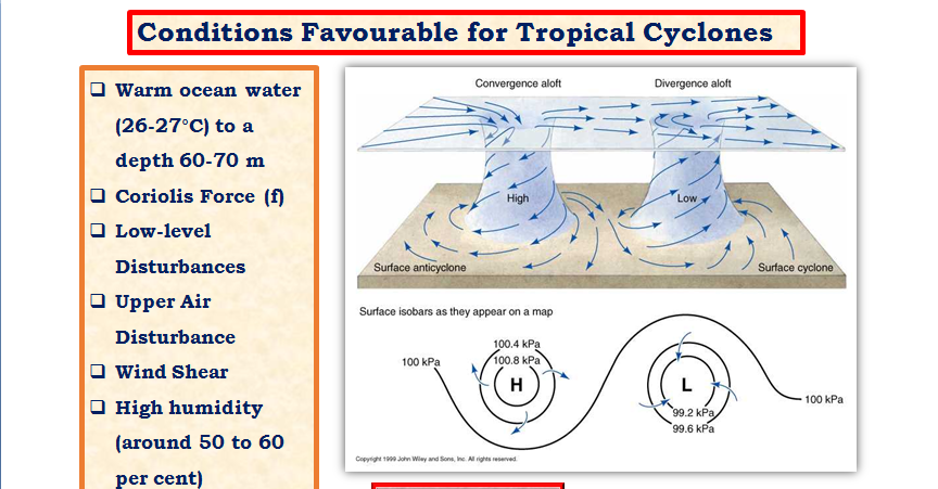
- Low-pressure systems associated with tropical cyclones can sustain themselves better with weak horizontal wind shear, as strong winds can disrupt the vertical upliftment necessary for cyclone development and maturity.
Structure and Vertical Profile of a Tropical Cyclone
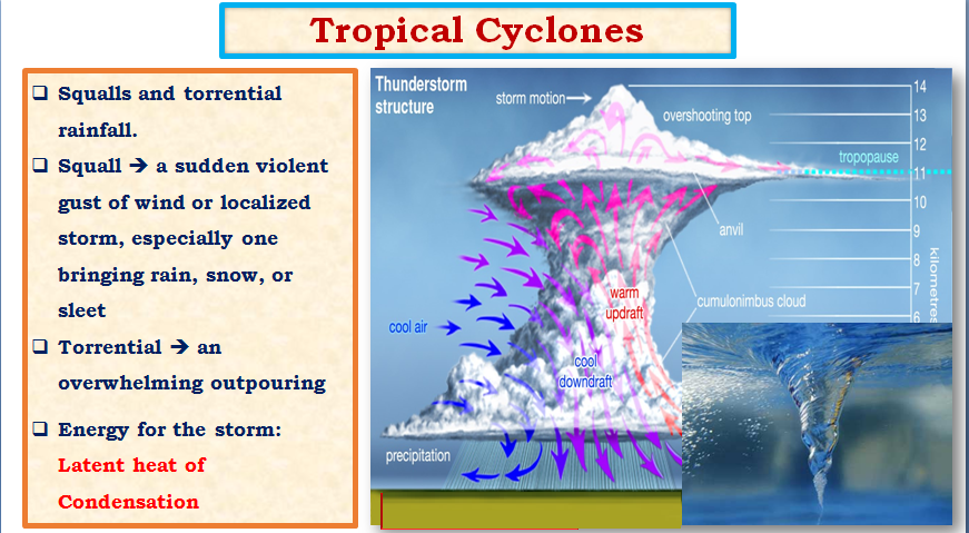
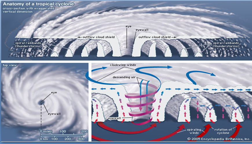
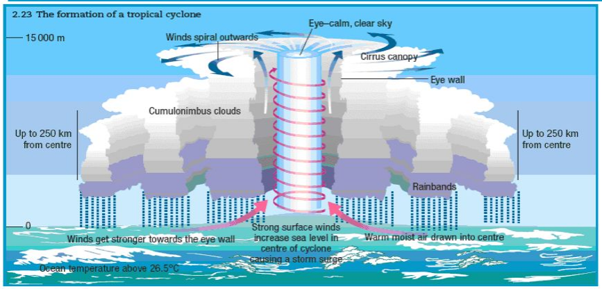
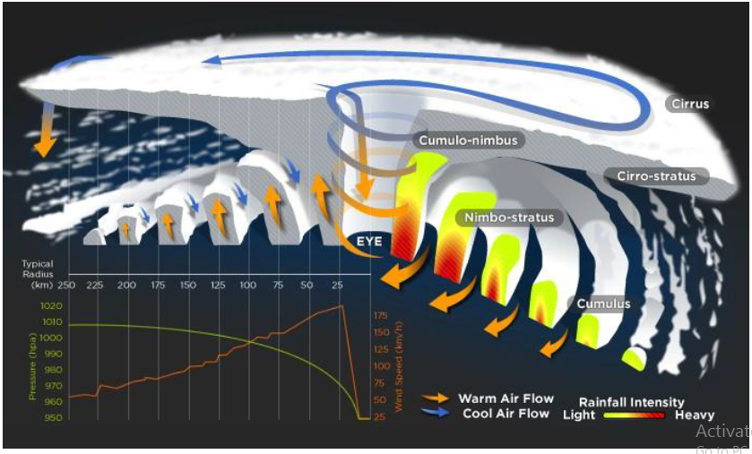
A tropical cyclone is characterized by its distinct structure and vertical profile. It consists of several key components, including the massive cumulonimbus cloud, the eye, the eye wall, and the spiral bands.
Massive Cumulonimbus Cloud and the Eye
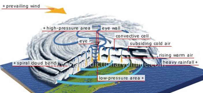
The central feature of a tropical cyclone is a massive cumulonimbus cloud with rapid converging air that spirals upwards along the wall of a central cylinder called the eye. The eye is roughly circular and is divided symmetrically by the cyclone into two parts. It is a region of low winds and fair weather found at the center of the cyclone. The eye may exhibit little or no precipitation, and sometimes a clear blue sky or stars can be seen. The eye is also characterized by the lowest surface pressure in the cyclone and warmer temperatures aloft, which can be 10 degrees Celsius or more higher than the surrounding environment. The size of the eye can range from 8 km to over 200 km across, with the most common diameter being approximately 30-60 km.
Eye Wall and Spiral Bands
The eye is surrounded by a circular ring of deep convection called the eye wall. The eye wall is an area of intense weather activity and has the highest surface winds in the tropical cyclone. It is where the maximum sustained winds, the fastest winds in the cyclone, occur. The eye wall is characterized by strong updrafts and downdrafts, which result in organized long and narrow rain bands oriented in the same direction as the horizontal winds. These rain bands spiral into the center of the tropical cyclone and are hence called spiral bands.
Vertical Structure of a Tropical Cyclone
The vertical structure of a tropical cyclone can be divided into three layers:
- Inflow Layer: This is the lowest layer, extending up to approximately 3 km. It is also known as the inflow layer and is responsible for driving the storm.
- Middle Layer: The middle layer extends from approximately 3 km to 7 km and is the main region of cyclonic storms within the tropical cyclone.
- Outflow Layer: The uppermost layer, above 7 km, is known as the outflow layer. This layer exhibits maximum outflow, typically above 12 km. The flow in this layer is anticyclonic in nature.
Weather Transition Across a Tropical Cyclone
The weather transition across a tropical cyclone follows a distinct pattern as one moves from the outer regions toward the eye. The sequence of weather changes is as follows:
- Light Winds and Scattered Clouds: In the outermost region of the tropical cyclone, winds are light, and there are scattered clouds with light showers.
- Increasing Winds and Heavier Rains: As one moves closer to the cyclone, the winds pick up speed, and the rainfall becomes heavier.
- Down Drought Winds and Subdued Rainfall: A brief period of downdraft winds occurs, resulting in subdued rainfall and calm conditions.
- Consistently Stronger Winds and Inner Cyclone: The winds continue to strengthen, leading to an inner cyclone with high wind speeds and heavy rainfall. The peak of this intense weather occurs at the eye wall.
- Eye of the Cyclone: Inside the eye, the observer experiences calm conditions with a clear sky, light variable winds, and no precipitation.
- Reversing Weather Pattern: As the observer moves out of the eye, they experience a reverse sequence of the weather pattern observed earlier. The strongest winds and heaviest rainfall gradually diminish as the cyclone moves over.
For individuals located within a tropical cyclone, the transition from calm conditions to intense weather and back to calm conditions can be a dramatic and potentially dangerous experience. It is crucial to closely monitor weather forecasts and follow the guidance of local authorities to ensure the safety and well-being of individuals in areas affected by tropical cyclones.
Life Cycle of a Tropical Cyclone
A tropical cyclone undergoes various stages throughout its life cycle, starting from its origin to its mature stage and eventual dissipation. Understanding the life cycle of a tropical cyclone is crucial for forecasting and preparing for its potential impacts.
1. Origin
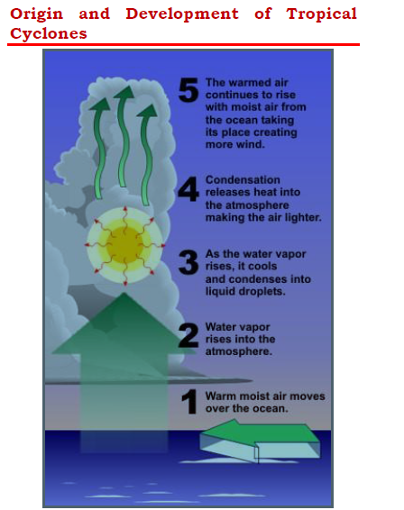
Under favorable conditions, multiple thunderstorms originate over the oceans. These thunderstorms merge and create an intense low-pressure system. Warm moist air moves over the ocean, and as water vapor rises into the atmosphere, it cools and condenses into liquid droplets. The condensation process releases heat into the atmosphere, making the air lighter. This process continues as the warmed air continues to rise, creating more winds and drawing in moist air from the ocean. The excess moisture over the oceans intensifies the thunderstorm, creating a cyclonic vortex due to the deflection of air caused by the Coriolis force.
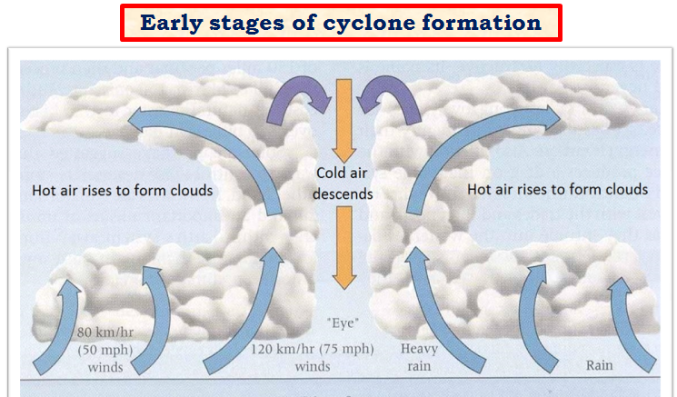
2. Early Stage
In the early stage, the thunderstorms uplift the air as it is warm and light. At a certain height, the temperature of the air falls due to the lapse rate and adiabatic lapse rate. The condensation process releases latent heat of condensation, making the air warmer and lighter, further uplifting it. This cycle of condensation and upliftment continues as long as moisture is supplied. The cyclonic vortex formed by the deflection of air due to the Coriolis force creates a region of calmness called the eye at the center of the cyclone, surrounded by the violent eye wall. The winds carried upwards lose their moisture and become cold and dense, descending back to the surface through the cylindrical eye region and at the edges of the cyclone. The continued supply of moisture from the sea is the major driving force behind every cyclone.
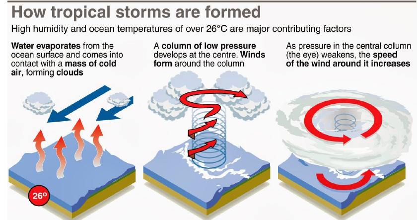
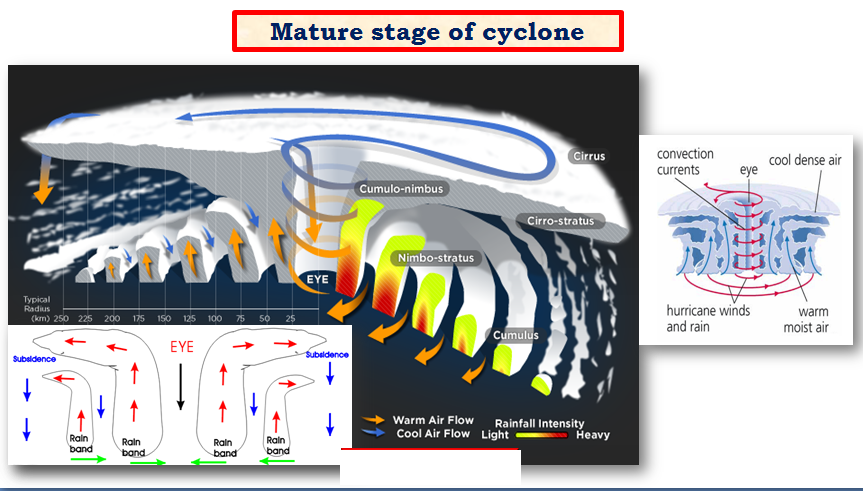
3. Mature Stage
In the mature stage, the low-pressure system reaches its strongest point with a well-developed eye and eye wall. The spiraling winds create multiple convective cells with successive calm and violent regions. Regions with cumulonimbus clouds, called rain bands, form below which intense rainfall occurs. The ascending air loses moisture at some point and descends (subsides) back to the surface through calm regions that exist between two rain bands. The cyclone begins to weaken when it hits land, as the supply of moisture is cut off. Eventually, the cyclone dissipates.
Understanding the life cycle of a tropical cyclone helps meteorologists track and predict its behavior and potential impacts. Forecasting and warning systems play a critical role in alerting communities in the path of a tropical cyclone, allowing them to take necessary precautions and mitigate potential risks.
Tracking and Movement of Tropical Cyclones
Tropical cyclones are a fascinating meteorological phenomenon that primarily occurs in tropical latitudes. These cyclones are under the influence of trade winds and exhibit distinct movement patterns. Understanding the tracking and movement of tropical cyclones is crucial for forecasting and issuing timely warnings to vulnerable regions.
Phenomenon of Tropical Cyclones
Tropical cyclones are a characteristic feature of tropical latitudes. They occur due to the interaction of warm ocean waters and atmospheric conditions. The trade winds play a significant role in influencing the movement of tropical cyclones.
Movement from East to West
Tropical cyclones generally move from east to west due to the influence of the trade winds. The trade winds blow from the northeast in the Northern Hemisphere and from the southeast in the Southern Hemisphere. This dominant east-to-west movement is a characteristic feature of tropical cyclones.
Preferred Location
The preferred location for typhoons is the Western Pacific and South China Sea, while cyclones are commonly found in the Indian Ocean. Hurricanes, on the other hand, are known to occur in the Atlantic. Along the northern coast of Australia, a type of storm called Willy-willies is commonly observed.
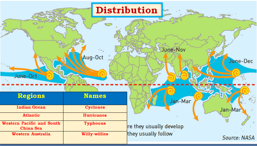
Favorite Breeding Grounds for Tropical Cyclones
Tropical cyclones tend to form in specific regions that are favorable for their development. Some of the favorite breeding grounds for tropical cyclones include:
- South-east Caribbean region
- Philippines islands
- Eastern China
- Japan
- Bay of Bengal
- Arabian Sea
- North-west Australia
- South-east African coast
- Madagascar-Mauritius islands
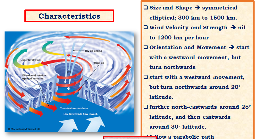
Characteristics of Tropical Cyclones
Tropical cyclones have distinct characteristics that set them apart from other weather systems. Some key characteristics include:
- Size and Shape: Tropical cyclones are often symmetrical with elliptical shapes and steep pressure gradients. They can range in size from 80 km near the center to as large as 300 km to 1500 km.
- Wind Velocity and Strength: The wind velocity within a tropical cyclone varies, with stronger winds typically found in the poleward margins compared to the center. Wind velocities in tropical cyclones can range from nil to 1200 km/hr.
- Path of Tropical Cyclone: Tropical cyclones follow a parabolic path influenced by the Coriolis force or Earth’s rotation and the prevailing easterly and westerly winds. They tend to weaken and dissipate at around 30 degrees latitude due to the cooling of ocean waters and increasing wind shear caused by the westerlies.
Warning and Monitoring of Tropical Cyclones
The detection and monitoring of tropical cyclones are vital for issuing timely warnings and taking appropriate precautionary measures. Various methods and technologies are employed to track and monitor tropical cyclones, including:
- Weather Stations: A global network of weather stations monitors changes in pressure and wind velocities in all countries, including the Arctic and Antarctic regions.
- Detection Radars: Countries with coastal regions, such as India, have detection radars along their coasts to monitor the approach of tropical cyclones.
- Aircraft and Satellites: Aircraft and satellites equipped with high-resolution radiometers operate in the visual and infra-red regions of the spectrum to provide real-time data on cyclone development and movement.
- Remote Sensing: Radars, aircraft, and satellites are utilized to gather data and provide advance warning and preparation measures, such as closing ports and harbors, suspending fishing activities, evacuating people, stocking food and water, and providing safe shelters.
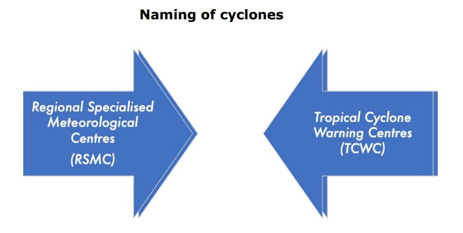
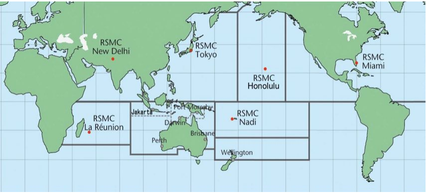
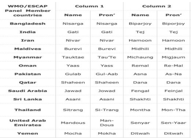
- Cyclone Naming: Tropical cyclones are given specific names to facilitate communication and tracking. Different regions and organizations follow naming protocols. For example, the Indian Ocean region uses names given by member countries, while the Atlantic and Pacific regions use predetermined lists.
The advancements in tracking and monitoring techniques have significantly improved the ability to detect and predict tropical cyclones, providing valuable lead time for authorities and communities to prepare and respond effectively.

Responses